Geography
Geophysical Characteristics
A.Location
Alcantara is a municipality of Romblon Province that lies on the southeastern seaboard of Tablas Island facing the Sibuyan Sea. It is bounded on the North by Sta. Maria, on the Northwest by Odiongan, on the East by Romblon Pass, on the South by Sta. Fe, and on the West by Looc; 12º22’ N to 12º12’22” S latitude and 122º6’ E to 122º2’ W longitude.
Alcantara is 45minutes by plane to Manila and 12 hours by boat. It is 3 and 4 hours, respectively, from Aklan and Mindoro by motorized bancas or pump boats.
B.Land Area Distribution
When the Municipality was separated from the mother town of Looc created simultaneously are barangays Comod-om, Madalag, Poblacion, Camili, Bonlao, San Isidro, Tugdan and Calagonsao. These Barangays have a survey of their boundaries and land areas. But when additional four(4) Barangays were created years after with its subdivisions/boundaries taken from their mother barangays, no survey was done up to the present. The municipality mainly relies on the tax mapping survey of the Provincial and Municipal Assessor which produced a data of the barangay’s land area. It is noted that Barangay Camili constitutes 23.41% of the total land area of the Municipality followed by Barangay Bagsik. Barangay Poblacion, the town’s center has the least area.
Table 1
Land Area and Distribution
BARANGAY | LAND AREA | PERCENT DISTRIBUTION |
Bagsik | 1,275.498 | 13.37% |
Bonlao | 557.136 | 5.48% |
Calagonsao | 1,185.822 | 12.43% |
Camili | 2,233.314 | 23.41% |
Comod-om | 384.462 | 4.03% |
Gui-ob | 312.912 | 3.28% |
Lawan | 288.108 | 3.02% |
Madalag | 613.422 | 6.43% |
Poblacion | 182.214 | 1.91% |
San Isidro | 197.478 | 2.07% |
San Roque | 1,064.664 | 11.16% |
Tugdan | 1,244.97 | 13.05% |
Source: Assesor’s Office | ||
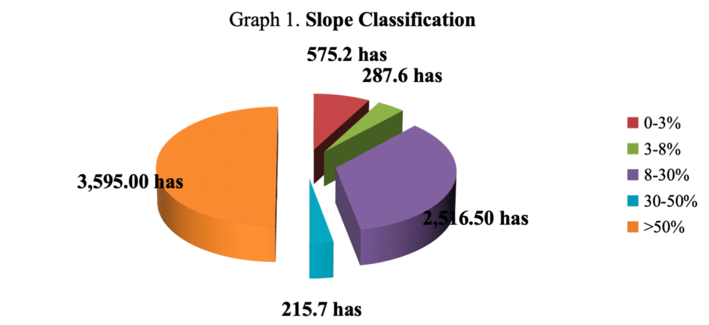
C.Topography And Slope
In general, Alcantara has a rolling terrain with slope ranging from 0% to above 18%. The topography of the municipality shows that of its total area, 15.04% belongs to 0-3% slopes, 16.69% to 3-8% slopes, 45.89% to 8-18% slopes, while the rest, which is above 18% constitute 22.38%. The overall terrain is suitable for pasture, tree crops and other agricultural crop development. The town is very hilly with almost all level areas are located in the coastal zone.
Table 2
Slope Classification
Slope Categories | Area (has) |
0-3% | 575.20 |
3-8% | 287.60 |
8-30% | 2,516.50 |
30-50% | 215.70 |
>50% | 3,595.00 |
Total | 7,190 |
D.Soil Characteristics/Composition
Soil composition developed from recent alluvial deposits. These are characterized by very deep surface and subsoil horizon with texture ranging from silty loam to clay loam. The upland areas are dominated by soil derived from igneous rock.
The Municipality of Alcantara has three types of soil distribution namely clay which covers 1,450 hectares, loam that covers 3,940 hectares and sandy which covers 1,800 hectares.
Alcantara has five general classifications of soil namely Laylay Sandy Clay Loam, Lonos Loam, Sta. Fe Loam, Sta. Fe Sandy Loam and Madalag, Faraon Complex. The Laylay Sandy Clay Loam, Lonos Loam, Sta. Fe Loam, Sta. Fe Sandy Loam are suitable to low land rice, coconut, corn and fruit trees, while the Madalag Faraon Complex is suitable for primary and secondary forest.
E.Geohazard
The Municipality is an island Municipality with most of its barangays(10 out of 12) are situated along the coastal area. Residents living near the shores are prone to storm surge as has experienced lately when strong typhoon like Frank occurred in the province. Big waves destroyed and carried away all the houses along the coastal areas. Affected families were evacuated and were not allowed by the Municipal Government to come back to their previous locations. Somehow, in other barangay like Lawan illegal settlers along the shores are still present and are increasing in number.
The inland barangays in the mountain areas are prone to landslide. Barangay Bagsik has experienced such calamity when families were covered with eroded soil sometime in early 1990’s. Such fatalities were not retrieved though heavy equipments were used during the rescue operation. Any structure was not allowed to be erected in the area since then. Other hazardous areas include those along the rivers wherein flashfloods occurred during heavy rains. Some fatalities and deaths were also recorded.
The fault line of the municipality is located near the shoreline along the municipal waters traversing the barangay proper of barangay Tugdan in where the Tablas Airport is located. So far, no indication has appeared yet that the fault line will move.
F.Climate
There are two distinct seasons in Alcantara: wet season from May to December, and dry season from January to April. The cold weather starts in December and ends in March, while the rest of the year, the weather remains to be warm. However, due to the effect of global warming, the Municipality and other localities are experiencing the abnormal climate that occurs.
G.Resources
There are two distinct seasons in Alcantara: wet season from May to December, and dry season from January to April. The cold weather starts in December and ends in March, while the rest of the year, the weather remains to be warm. However, due to the effect of global warming, the Municipality and other localities are experiencing the abnormal climate that occurs.
- Mineral Resources
The Municipality of Alcantara is rich in mineral resources. Copper can be found in Barangay Camili while there are Iron in Barangays Camili and Tugdan. Clay is present at Barangay Camili and San Isidro but these minerals are not yet explored. Gravel and sand, a non-metallic resources are abundant in the municipality which could be found in the coastal areas and the rivers.. Nearby municipalities like Looc are quarrying in the river of barangay Calagonsao since the river was the only place allowed to be hauled with gravel, sand.
- Water Resources
Almost all the Barangays within the Municipality has abundant source of water. These sources of water mostly Spring were developed and were tapped thru CIDDS program and other programs that followed from the Department of Social Welfare and Development. Such Barangays with Level III water supply system are Poblacion, Camili, Bagsik, Comod-om, San Isidro, Bonlao, San Roque, Tugdan and Calagonsao. However, due to illegal cutting of trees and abuse of the watershed area, water tend to be scarce especially during dry season prompting most of the hoseholds to source out water from jetmatic pumps. Barangay Poblacion has the worst problem.
- Forest Resources
Based on the province’s PPFP, the municipality does not have any forest cover though it has around 24.9 square kilometers of land categorized as non NIPAS. Despite the absence of forest tree species, there are two forest products that are available in the municipality. These are Nito and Huwag. Nito can be found in Barangay Bagsik, Calagonsao, Camili and Comod-om. Huwag on the other hand can be found in Barangay Bagsik, Calagonsao, and Camili.